
Yannick de Raaff, Groningen Institute of Archaeology, University of Groningen
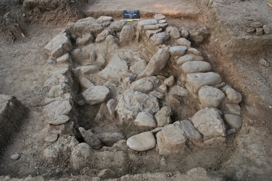
In this blogpost I would like to illustrate how and why we have applied digital techniques (photogrammetry and Virtual Reality) to solve a specific archaeological problem. Our study concerns the architecture of a Bronze Age (early Mycenaean; ca. 1700-1420 BCE) tomb from the North Cemetery of Ayios Vasileios, Lakonia, Greece. This particular tomb (called Tomb 21) is roughly rectangular in shape (inner dimensions ca. 2.26 x 1.33 m), and was filled to the edge with a large mass of some 200 stones, evidently the remains of a roof (figure 1). However, even after the complete removal of all the stones, careful recording and the excavation of inhumations underneath we were unsure about the original shape and construction of the roof. How would this hodgepodge of stones once have formed a cover, and how had it collapsed? Rebuilding the roof in real life was not possible, since the tomb had been backfilled after the excavation was completed. Therefore, we decided to address this issue by using digital techniques.
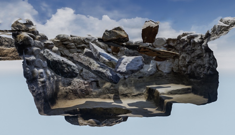
With the financial help of several grants we started working together with the Virtual and Augmented Reality experts from the Reality Center of the University of Groningen. A VR-environment was created in Unreal Engine using a surface model of the empty tomb, and 3D models of the collapsed stones were made and added to it. Both the interior of the excavated tomb and the stones were modelled with Structure for Motion (Sfm; also called photogrammetry). The VR-environment offered us three main advantages. Firstly, we could scrutinize the still standing walls of the tomb from any angle, even after completion of the excavation. Secondly, by carefully studying the various photographs and videos of the collapsed stones as they were being excavated, we could approximate their position within the tomb and place them in that position within the VR-environment. That allowed us to better understand the relative position of the various stones within the tomb and vis-à-vis each other, and thus the collapse (figure 2). Lastly, the stones could be restacked interactively in an attempt to recreate/approach the original appearance of the tomb’s roof and explore which types were likely and which were not.
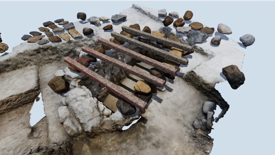
After the modeling, programming and the gathering of parallels of contemporary tombs, it was finally time to put on the VR-goggles, strap on the controllers, and start with our life-size three-dimensional puzzle. Weeks were spent in the virtual tomb, labouring under a virtual Greek sun, grabbing stones with the controllers, moving them around, putting them in place, pressing the ‘save’ button, and trying again. After many attempts, we were able to confidently refute a number of designs – most likely, the tomb was first covered by a series of beams on top of which were placed first the largest slabs (these were found deepest inside the tomb and must therefore have fallen down first), and then the remainder of the stones were placed on top, creating a cairn (figure 3). Judging by the way the stones had fallen down, it seems likely that the beams broke and caused first the slabs and then the rest to tumble inwards. Instead of merely hypothesizing about the tomb’s cover and its collapse, the digital techniques have made it possible for us to test hypotheses in a structured and argued manner. Virtual Reality was in a way used to perform experimental archaeology in a digital environment. (For further information, see the embedded video below.)
The project is included in the DIG IT ALL-exhibition of the University Museum (University of Groningen), and so is the video added below this blogpost. More information on the exhibition can be found on the website: https://www.universiteitsmuseumgroningen.nl. The exhibition is part of the centennial celebrations of the Groningen Institute of Archaeology and includes various other archaeological projects that have included innovative digital techniques. Our project has been presented so far at various conferences (click link for PowerPoint presentation), and a scientific article will appear in the proceedings of the Lakonia conference.
The excavations at the Ayios Vasileios North Cemetery are directed by Sofia Voutsaki, as part of the Ayios Vasileios Project, directed by A. Vasilogamvrou, Director Emerita of Laconia Ephorate, and carried out under the auspices of the Archaeological Society at Athens. Our thanks go out to the Groningen Institute of Archaeology (GIA), the Ammodo Foundation, the Institute of Aegean Prehistory, the Mediterranean Archaeology Trust and the Centre of Digital Humanities. This reconstruction project was a collaboration between archaeologists from the GIA (Yannick de Raaff, Sofia Voutsaki, Theo Verlaan and Gary Nobles) and staff of the Centre for Information Technology, interfaculty V / AR hub (Gert-Jan Verheij, Frans van Hoesel and Pjotr Svetachov.
Recent Comments